FRIENDS of ... 

SALTA

Through the Iruya riverbed
"An excursion on horseback from Iruya to Orán"
Nicolás Bello and Nora María Bello

Page 1

Written by Nico Bello in August 2003.

We arrived in Iruya on a beautiful afternoon of August 2, 2003, the weather and the prevailing temperature encouraging us about the journey that we would start the next day.

We stayed at the Provincial Inn where Gloria welcomed us with the usual local cordiality. After a dinner of typical meals of the area, we were presented with a demonstration of the popular art of the Altiplano (highlands). The local people, making use of the erque, erquencho, box and flute to accompany their typical dances and recitations, gave us a beautiful evening, just like the place itself.

After the applause we headed to prepare our saddlebags with what was necessary to start our journey the next day. Meanwhile, Martín and Miguel, who would be our guides and baqueanos (kind of a locally-attuned companion), had already prepared the rides with good horseshoes and better aperos (aka local saddles).

Early the next day, we saddled our animals, distributing a light load between the four and balancing well the rest of the cargo on the freight horses, and left at about 9 in the morning of a sunny winter day.

The playa (sandy riverbed) of the Iruya River received us with its usual aridity. We accommodated ourselves on the aperos (local saddles) and started the ride. We had several days ahead during which our companions would be the river and the high ravines that enclose it, the hills full of countless colors meanwhile so replete of irregular formations that it is impossible to get bored of the landscape. The aridity was absolute.

Our GPS indicated 2740 meters over sea level when we started the descent downstream.

1 - General view of the town of Iruya and the riverbed and gorge downstream.
2 - On the playa (sandy riverbed) of the river.

The small town of Iruya is the capital of the homonymous Department (county) of the Province of Salta, a peculiar highland town nestled among the high hills that press it against the river ravine of the same name. Its cobbled and narrow streets offer a different set of features to the visitor. The town of Iruya has approximately 1800 inhabitants; in spite of the reserve that characterizes local manners, people in Iruya are more communicative than in other towns of the highlands and spontaneously offer themselves to the outsider trying to discover it.

Iruya is surrounded by southern hamlets such as Toroyoc, Campo Carrera, Pueblo Viejo, Campo Grande and Colanzulí, towns all guarded by the imposing Cerro Morado that towers 5008 meters above sea level. All of them have access roads for cars, and traveling through them, it is interesting to observe the particular life and customs of its inhabitants. There are extensive terraces of crops which are still worked manually, or at most, helped by oxen to pull the local plow, known as arado de mancera. The main crops consist of Churqueña potato, red potato, green potato, Andean potato, ocas, various types of kidney beans, and corn in its many different varieties and colors, which stands outs when prepared as delicious "mole" (type of stew). They also grow alfalfa, barley and other local varieties of grasses as the main fodder for their animals during winter.

In the north there are numerous towns such as San Isidro, San Juan and many others, inaccessible to the common traveler, since they can only be accessed by 4x4 vehicles, or in some cases, only on horseback. San Isidro is as noteworthy for the quality of its handmade weavings as for being a picturesque hamlet nestled in the junction of two streams, with its houses hanging from the hills around its chapel.

After traversing the gorge that gives access to San Isidro, we made a stop with the intention of visiting the pre-Hispanic city of Titiconte. We loosened the aperos, secured the animals and crossed the river in search of the homestead of Doña Julia Canchi's, who was laboriously trying to milk her goats. We asked for directions and embarked on an arduous and dangerous climb towards our objective. After two hours of trekking, behind some hills, we started to see a great plain in the distance, where large cultivation terraces and abandoned remains of very old buildings were apparent.

Cultivation terraces in Titiconte.


TITICONTE

This settlement was discovered, excavated and studied in 1930 by an expedition commanded by two eminent men of science, Drs. Salvador Debenedetti and Eduardo Casanova, who, years later turned all their experiences into an interesting publication of the Ethnographic Museum of Buenos Aires; it was simply titled "Titiconte". A few years later, these ruins were visited and studied by Dr. Fernando Márquez Miranda, giving rise to an interesting narration published by the University of La Plata with the title, "Four study trips to the most remote Argentine Northwest."

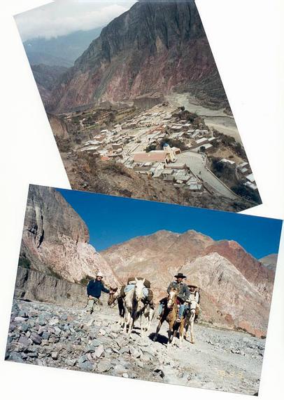
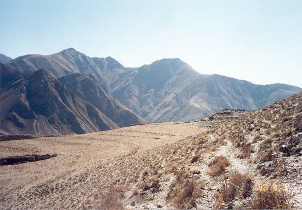
As we neared our destination, we were presented to our left with the main and large cultivation terraces, on which at first glance we observed a great job of despedrado (removal of rocks and stones) that contrasted with the surrounding land. To our right, there were parts of the 28 terraces that once existed, all different in shape to the previous ones, long and narrow, that ascend the slope supported by sturdy, but today partially collapsed, stone walls.

When arriving at the citadel, we noted how destroyed its constructions were, mostly old houses and old collcas once used to save grain, all ransacked across a wide area by decades of countless visitors with careless and destructive attitudes. Consider also that the excavation work was done by researchers in times when excavation was not systematized, when there was not a school that guided and regulated the excavations and searches for ancient remains.

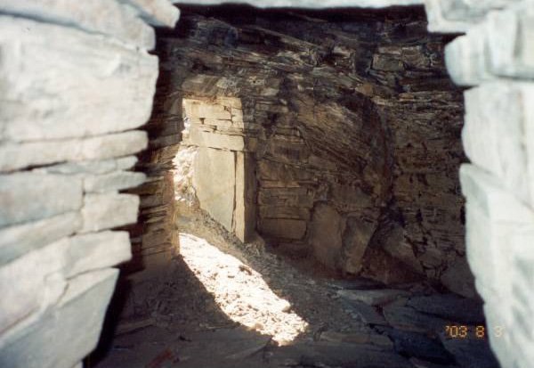
There are collcas, the least of which are in good condition, highlighting well-worked stone floors and roofs built with large slab stones. Their access doors are striking, just like those of the remains of houses, framed in large slab stones placed as jambs and lintels. This form of construction is rarely seen in other sectors of Argentinean Northwest, but very typical of this area, even to this day.

4-Interior of a collca.

  Behind Titiconte the steep ravine of the Blanco River guarded the citadel against intruders from the south. The only possible access to the citadel was the perilous road on which we arrived, a feature that safeguarded the people by means of its 360-degree view.

  So isolated and hidden is this place and its broader area, that Eric Boman, in his book "Antiquities of the Andean Region of the Argentine Republic and the Atacama Desert", which left no other place of the Argentinean Northwest undepicted, called it "Terra incognita".
He could never visit it.

Ing. Nicolás Bello


Continue on... Page 2

See Satellite Photo of this sector


Back to the Friends of VIAJEROS4x4 Menu


Back to the SALTA menu

Back to the VIAJEROS4x4 main menu