FRIENDS of ... 

SALTA

Through the Iruya riverbed
"An excursion on horseback from Iruya to Orán"
Nicolás Bello and Nora María Bello

Page 4

Written by Nico Bello in August 2003.

15-Gorge of the Iruya river.

It is worth pointing out again the abundant wood in the area, in sharp contrast to the rough rocky landscape of recent days. Everything was not only made of wood, but also made with wood. The machete, along with the long-end ax on the shoulder, were ubiquitous as if part of the humanity of every person. Evidence of the modern chainsaw was found in some places, only a few really, such as the careful cuts in boards and braces.

The high stone struts in the manner of jambas (jamb doorposts) on the doors, similar to those observed in Titiconte and several other places of our route, had given way to thick wooden jambs and lintels.

Fire, so scarce upstream, accompanied each household that we observed in the surroundings all day long.

The rudimentary stone mills were observed everywhere, not missing in any yard. A group of teenagers laughed at the curiosity that these mills arouse in us. There were so many types and sizes that it was really necessary to stop to look at each of them, with constant amazement.

The day had dawned, and we were with our horses by the riverbed. A tractor with a high trailer had arrived in Matancillas coming along the downstream river the previous evening; it brought materials for the school and helped locals move around the area. The tractor rode on a rough path that meets the river numerous times. It tows a high trailer, which was necessary to keep water from reaching the people and things it transported through the frequent river crossings. At noon, the tractor passed us, loaded with people and merchandise, and with its purring engine it rode down the river in search of Isla de Cañas.

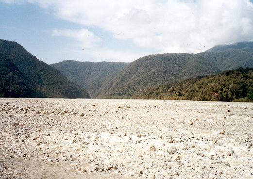
We passed the narrow of Aguas Calientes. To the north, a brook of warm waters lent its name to this place so full of greenery. Shortly afterwards, a large expanse of riverbed opened in front of us. Here, the river channel was so ample that we could securely estimate it to be at least 700 or 800 meters wide in this area. We had reached Monoyoc, a place of great ravines where the locals bring their animals in winter to graze in the absence of grass in the arid highlands. The beauty of the place left us amazed. A great glen opened to our left towards the North, then after crossing the Abra de Monoyoc, descending to the sources of the Pescado, another important river in the great Bermejo basin.

A large esplanade allowed the settlement of the Monoyoc estate, a modest house made of large boards, with countless birds and monkeys stunning with their characteristic songs and squeaks, hiding among the large trees of the place. Here lived Don Eustaquio Mamaní and his wife, though they were currently absent. We observed a large corral made of dry-seated stones and numerous horses that enjoy this paradise at ease.

16-Monoyoc.


TRIGONOMETRIC POINT

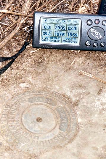
Having reached Monoyoc, we identified a trigonometric point of IV order (Doppler) of the Military Geographical Institute (Institute Geografico Militar or IGM) and with it, we took the opportunity to analyze the accuracy of our GPS. Having visited the IGM headquarters located at Cabildo Avenue in the city of Buenos Aires, Argentina, we had obtained the access monograph for this trigonometric point, which is identified as number 12 of topographic chart 2366-II entitled "La Quiaca." Its complete identification is: 3A-IV-3033 and its monograph describes the access to it from San Ramón de la Nueva Orán. Its geographical coordinates are S 22º 48’ 37,8100’’ W 64º 49’ 03,2850’’. Its height is 1054 masl. It was installed in November 1987 on a concrete block 50x50x80 cm deep. A thick white-painted pipe caught our attention, directing us to the exact location of the point.

Our GPS marked 1075 masl. We activated the GOTO function of our Garmin III+ and after selecting the datum of Campo Inchauspe, it deposited us about 8 meters from our target.
The visibility and number of satellites captured by the GPS device was complete. We believe this to be a good performance for these types of devices, at least for these purposes. We had activated the mentioned datum thinking that the new Datum WGS84 currently in place was not yet in use in our country in November 1987, when the IGM trigonometric point was installed. On the contrary, when activating the Datum WGS84 in our GPS, we were deposited 120 meters away from our target.
Surely Campo Inchauspe proved we were in the right Datum.

17-Trigonometric point from the Military Geographic Institute (IGM) in Monoyoc.


While we watched and enjoyed this whole landscape full of green and solitude, our horses scattered across the wide glen looking for the green and juicy pastures that had been so elusive and scarce the previous days. We ate something quickly and, crossing the wide riverbed, we continued our way downstream.

18-Riverbed of the Iruya river in Monoyoc.


The Iruya river continued to increase in volume, its augmented flow hindering more and more the river crossings we were forced to make. The water reached the belly of my mule, with whom I had already made good friends. He ate eagerly the orange peels that I offered, but only after watching me closely and suspiciously. Great walker this mule was. His name was "Huesito" (little bone).

On the banks of this particular river and between the thicket of the jungle, we began to see open fields that announced the presence of work fields advancing over the surrounding slopes. The dense jungle of large trees had changed the landscape of the arid Puna in the area of the town of Iruya. Cebil, quina, flowered lapachos and many other tree varieties were the inhabitants of this place. We approached the narrow of San Ignacio. The waters, although calmer, had become abundant flow. After transposing the narrow, we approached the school of Limoncito located on a hilltop on the northern margin of the Iruya.

It was six o’clock in the afternoon when Ruth Ormachea, teacher and principal of the school, with her many students welcomed us. In the company of Miguel and Martín, we turned out the horses in the large school grounds. The joy was widespread, partly because visitors are not common to these places, which is not to say, nonexistent. They invited us in and served us delicious mate tea and homemade bread, as the afternoon lingered and the talk continued into the night. It was the end of a sunny day full of luminosity and colors.

19-School of Limoncito.

The day dawned cloudy and a persistent drizzle threatened the continuation of our excursion. The school routine developed normally, the kids with their notebooks and books completing their homework, and more than one requesting our help. Pedro didn't do very well with the instructions I gave him. After doing his homework with my help, he quickly approached the teacher to get her approval; I don't know what happened but I noticed that the teacher sent him back to redo the work again. Poor Pedro, I don't know what could have happened.

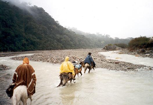
Around noon, we put on our capes and decided to continue downstream in search of Isla de Cañas, our next goal. At that point on the route, the river margins were no longer so vertical and allowed us, for the first time, to get out of the riverbed and accompany the river downstream along a parallel path. We passed through El Tuscal, where the fences showed us the first signs of civilization. We advanced through galleries of large trees that, with their greenery and tall trunks, accompanied our passage.

20-Crossing the Iruya river.

Ing. Nicolás Bello


Continue on... Page 5

See Satellite Photo of this sector


Back to the Friends of VIAJEROS4x4 Menu


Back to the SALTA menu

Back to the VIAJEROS4x4 main menu