FRIENDS of ... 

SALTA

Through the Iruya riverbed
"An excursion on horseback from Iruya to Orán"
Nicolás Bello and Nora María Bello

Page 5

Written by Nico Bello in August 2003.

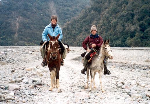
In the middle of the afternoon, we arrived at a small building located on a high point along the river: the capacity station of the Iruya river. A long steel cable extends over 200 meters, the river’s width in this sector. A small trolley slides along this cable, and specialized personnel make daily measurements throughout the year in order to study the conflictive behavior of this river.

21-Arriving at the capacity station.


CAPACITY STATION of the Iruya River

Under the drizzle that persisted, stopping our passage, we talked at length with the people in charge of the station, who kindly answered our countless questions. The talk was friendly and they began to offer data that were interesting to us and that helped us understand the behavior of the river. At that moment, the river had a flow rate of 10 m3/second, although at this time of the year (i.e. dry season, winter) it usually reaches 6 m3/second. In summer, over the rainy season, its average flow oscilates around 250 m3/second, reaching maximum flow rates of around 400 to 450 m3/second.

We were at 948 meters above sea level, and evaluating these data, we began to appraise the great movement of this river. We noted that in 72 km of route, we had descended 1802 meters in altitude. The average slope was 2.5% with a maximum of 5.1% between Iruya and Higuera. We began to understand why this river is considered one of the largest in South America in terms of solids transport. To given dimensional perspective of this phenomenon, between 20 and 2000 tons of solids per hectare and per year are transported. Such sediment dragging is the primary culprit for the lion color of the Paraná River and the high purification costs of the water consumed by the towns and cities located on its banks. Moreover, the high dredging cost of the access channels to the port of Buenos Aires makes this one of the most expensive and irrational navigable ports in the world. The sediments that year after year transform the Paraná Delta have the same origin. More than 60% of the solids that the Paraná river transports come from the Iruya, a small and almost unknown river, whose torrential waters, for over 160 years, experts have sought to control. The first reports on the upper Bermejo river basin date from the 1840s.


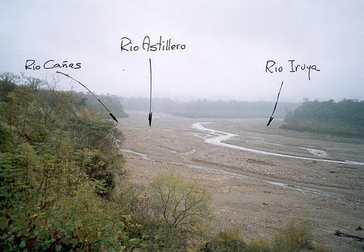
We followed our path between tall trees and dense vegetation. Not far from here, the Iruya river received from the south the waters of two important tributaries, the Astillero and the Cañas.
Rivers of very different characteristics, their wide channels with large boulders provided a new physiognomy to the Iruya river

22-Junction of the rivers Cañas, Astillero and Iruya.


Through a narrow trail that made its way through the high ravine of the river, we entered Isla de Cañas, a relatively new town, founded around the early 70s, well laid out, with wide streets and generous sidewalks. After a brief tour, we observed that the numerous existing sawmills must dominate the local economy. A very well maintained city hall stood in front of the main square and, a few blocks away, an important soccer field entertained many residents.

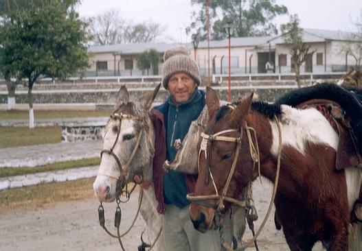
With nostalgia, we said goodbye to our faithful mounts. Our cordial friends Martín and Miguel promptly started the return to Iruya after resting comfortably.

23-In the main square of Isla de Cañas.

The next day we loaded our backpacks and started, by pickup truck, the last section of our trip, to San Ramón de la Nueva Orán. The road quickly entered a wide glen completely covered with abundant jungle vegetation where it is no longer observed, nor even imaginable, that in the past, the Iruya River ran to dump its waters into those of the Blanco or Zenta River.

Since being founded on July 16, 1794 by Don Ramón García de León y Pizarro, San Ramón de la Nueva Oran has suffered from the onslaught of the Iruya and Zenta rivers, the large floods of which drained a 4500-km2 basin and covered the city in mud. In the year 1865, after numerous studies, it was decided to divert the Iruya river from the Portezuelo del Portillo, near the present day Isla de Cañas, to cut over a low hill called Pintascayo, towards the Pescado River, near the Pescado lagoon, which was a short distance away and 60 meters lower in altitude. As soon as the work began, the first floods facilitated the task of diverting the river, opening over time a large channel through which the Iruya circulates today, after receiving the waters of the Black and Piedras rivers and searching for the Pescado river, to finally join the Bermejo.

Large trees tightened the road that, among such lush vegetation, gradually escaped from the Oranian jungle to make way for the large field expanses worked by the Ingenio San Martín del Tabacal. We were already at the gates of Oran, an industrious and thriving city of Salta in our northern Argentina.


EPILOGUE:

We would like to finish this story with a paragraph from the book "El Alto Bermejo - Realities and Conflicts" by a great scholar and connoisseur of this whole area, Mr. Carlos Reboratti:

"The high basin of the Bermejo River has the dubious honor of being one of the most isolated regions of the country, and one of the least known. Even though it has very high poverty and marginality rates (or perhaps precisely because of that) the high basin of the Río Bermejo does not seem to be a region with problems for governments or for the general public."

Nicolás Bello
Civil Engineer
 
Nora María Bello
Veterinary Medical
 
La Cumbre, Córdoba province - August 2003
 
Translation:
Keith Sterner
Gina Becker
Nora María Bello


BIBLIOGRAPHY:

*Boman Eric - Antigüedades de la Región Andina de República Argentina y del desierto de Atacama. – Universidad Nacional de Jujuy, 1992

*Casanova Eduardo – Excursión Arqueológica al Cerro Morado – Notas del Museo Etnográfico de Buenos Aires, No: 3 Año 1930.

*Colmenares Luis Oscar – Una labor sin fallas: la fundación de Orán. – Academia Nacional de Historia, Tomo I Año 1977.

*Debenedetti Salvador y Casanova Eduardo –Titiconte. – Publicación del Museo Etnográfico de Buenos Aires, Serie "A" III Año 1933-1935.

*Marquez Miranda Fernando – Cuatro viajes de estudio al más remoto NOA. – Revista del Museo de La Plata, Antropología No: 6 Tomo: I.

*Reboratti Carlos – El Alto Bermejo-Realidades y Conflictos. - Editorial La Colmena, Julio de 1998.


How this story began

See Satellite Photo of this sector

In 2019 we came back to help a school


Note from "TRAVELERS"

For site readers who enjoy extreme crossings in their vehicles:

Being in Iruya, the villagers told us that in times of stying (low flow of the waters) they usually go down to Oran by the bed of the Iruya River, but that they only achieve it with Ford F350 trucks.

The challenge is posed and can be excellently combined with a solidarity action for the schools mentioned by Nico in his account.

If you liked this note you can share it on your wall so your friends can also see it   Compartir en Facebook   Compartir en Facebook

For Whatsapp copy and paste: http://www.viajeros4x4.com/a_amigos/bello/iruya/iruya_0.htm


How to get to Iruya (spanish)

An excursion beyond Iruya (by motorcycle) [Spanish]


Back to the Friends of VIAJEROS4x4 Menu


Back to the SALTA menu

Back to the VIAJEROS4x4 main menu